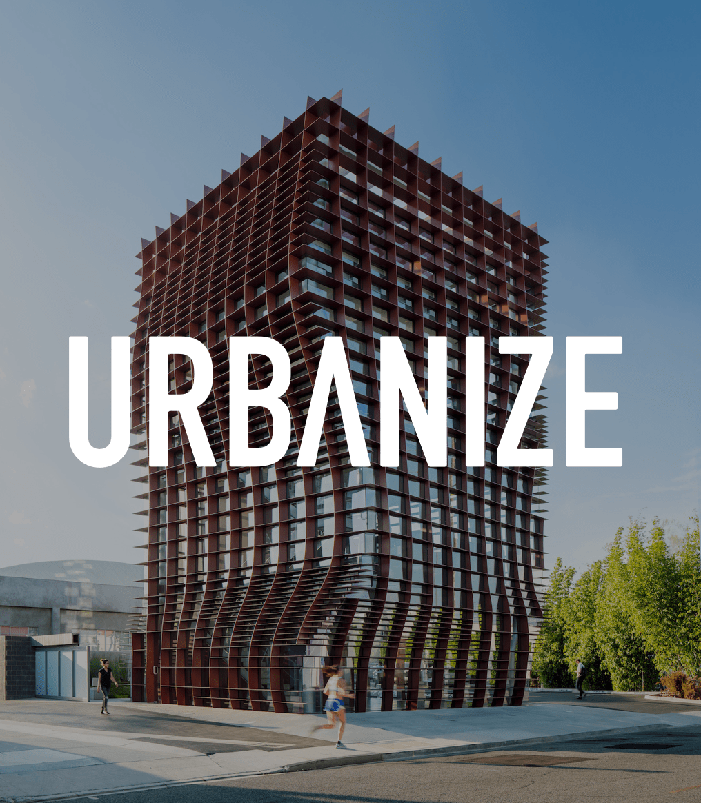
Earlier this month, the Los Angeles Department of City Planning has released its latest draft of the Exposition Corridor Transit Neighobrhood Plan, which is intended to regulate land use surrounding Metro's popular Expo Line.
The proposed standards touch on several areas of the development process, including zoning, urban design, streetscape standards and building design. The latest update includes several changes which, depending on one's perspective, either improve or degrade the utility of the plan. They read as follows:
- An increase in the percentage of residential use permitted in the proposed “Hybrid Industrial” zones;
- An alternative compliance option to allow select sites planned for more intense commercial uses to be developed with a greater proportion of housing, with increased public benefits requirements;
- An increase in the percentage of live/work units that can be developed in the “New Industry” Zone;
- Removal of the proposed R3 subarea along Exposition Blvd. between Sepulveda and Westwood Blvds;
- Removal of the proposed RAS4 subarea along Pico Blvd. between Sepulveda Blvd. and Overland Ave.;
- Eliminated “Tier 1” of the Bonus FAR system; all projects using the Bonus FAR are required to provide affordable housing in addition to other public benefits.
- Adjusted affordable housing requirements to be consistent with affordability levels required by the Measure JJJ Transit Oriented Communities Guidelines (7% Extremely Low Income, 11% Very Low Income or 20% Low Income of total proposed units).
- Created flexibility in allowable retail and restaurant use in the New Industry and Hybrid Industrial zones
- Refined development review processes for projects complying with the Plan.
- Added a new proposed Mixed Use: Commercial/Residential subarea along the south side of Pico Blvd. between Westwood Blvd. and Overland Ave.
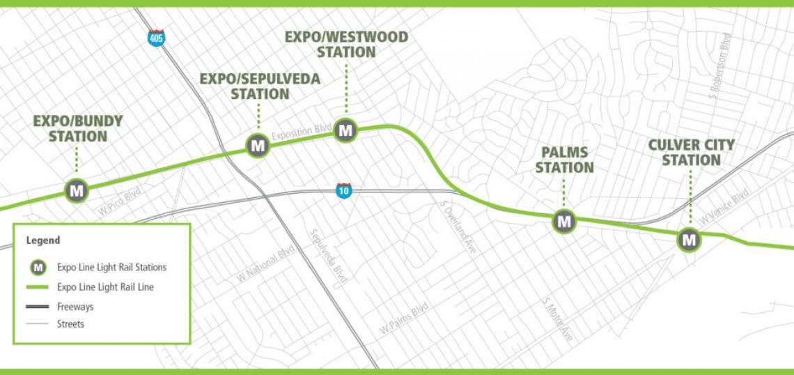
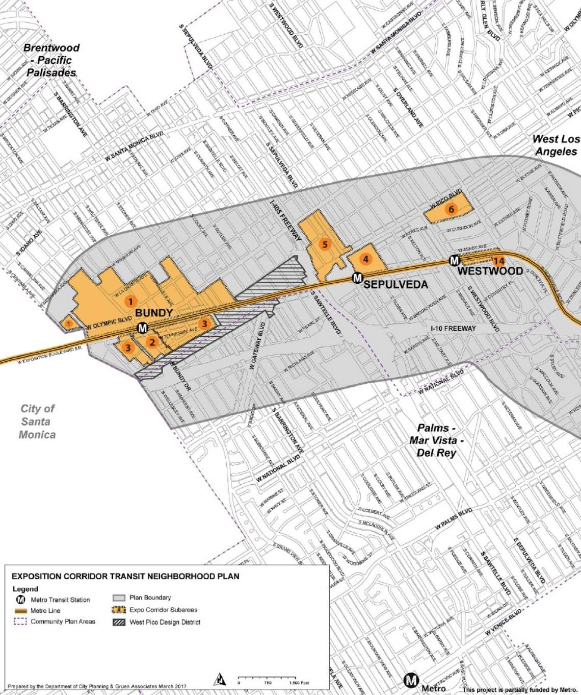
Roughly speaking, the Expo TNP consists of all properties within a roughly half-mile radius of the Expo Line between Culver City Station and Expo/Bundy Station. This includes roughly 2,000 acres of land, in which somewhere between 4,400 and 6,000 new residents and between 9,400 and 14,300 new jobs are expected by the year 2035.

Most of the area covered by the Expo TNP is subject to rules changes that are merely cosmetic. New construction on properties zoned R1 and R2 will be subject to the urban design and streetscape standards of the plan, but not the new development regulations.
More intense development is restricted to the subareas designated in orange on the maps above, which total approximately 256 acres. The result would be modest increases in zoned capacity along certain commercial corridors - such as Venice Boulevard and Motor Avenue - and for some existing multifamily zones.

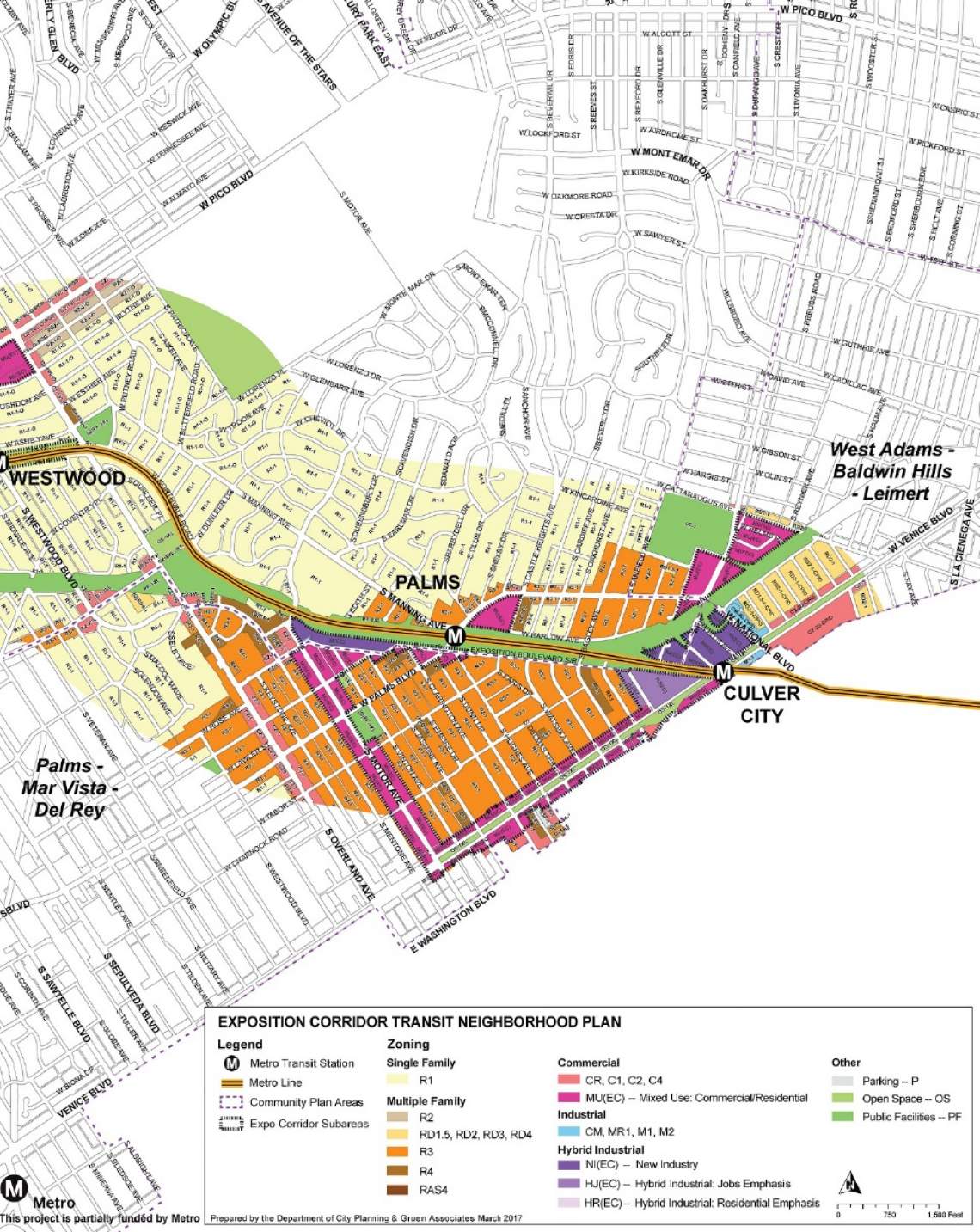
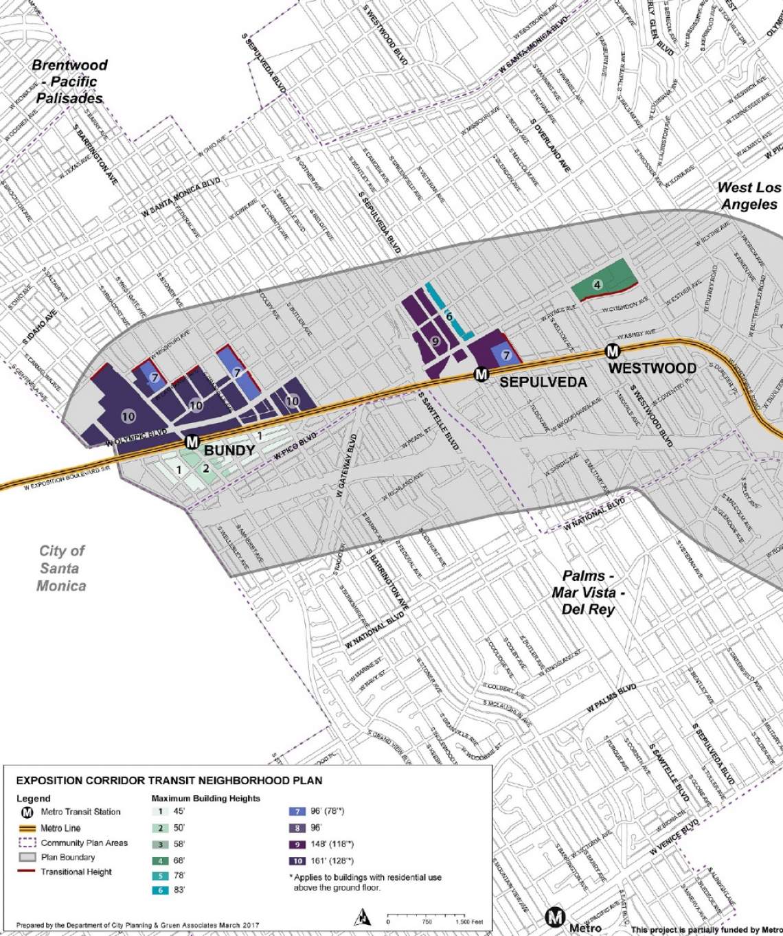
The Expo TNP would also allow for more intense land use on several properties near the Culver City, Palms, Expo/Sepulveda and Expo/Bundy Stations. Most of these sites would fall under the "New Industry" zone, which prohibits residential development and encourages creative industry employment.
New Industry zoning allows for a max floor area ratio of 4:1, and would permit buildings as tall a 161 feet near the Bundy and Sepulveda Stations. Heights would be capped at a more modest 96 feet near the Palms and Culver City Stations.
Other properties near the Bundy, Sepulveda and Culver City Stations would be zoned as Hybrid-Industrial. This zone - which also allows a max floor area ratio of 4:1 - was designed to promote residential development in transitioning neighborhoods while simultaneously preserving job-creating industrial land. It achieves this goal by allowing for live/work units, a product that is most commonly seen in the Arts District on the east side of Downtown Los Angeles.

As has become a standard in most new construction in Downtown Los Angeles, the proposed Expo TNP calls for unbundling parking for most new construction within the station subareas. This means that habitable spaces will be rented separately from code-required parking spaces. However, unbundled parking will not be required for properties in areas zoned R3 or less.
Other reductions or changes to parking policy include reductions for:
- Vehicle sharing
- Shared parking across different uses within a project.
- Affordable housing.
Projects in areas zoned higher than R3 would also be required to provide transit passes to employees and residents.
Urban Design Standards
The Expo TNP would also require pedestrian-friendly orientation for new construction along commercial corridors and other major streets, including segments of:
- Palms Boulevard
- National Boulevard
- Venice Boulevard
- Motor Avenue
- Overland Avenue
- Pico Boulevard
- Westwood Boulevard
- Sepulveda Boulevard
- Sawtelle Boulevard
- Olympic Boulevard
- Gateway Boulevard
- Bundy Drive
- Barrington Avenue
The proposed urban design standards call for street-facing entrances, limited use of fencing and uniform building setbacks, among other items. In short, the regulations would mandate pedestrian-oriented buildings along commercial boulevards, with similar aims to the design districts proposed in Westlake and West Los Angeles.
What does this mean?
While a small but significant step towards a more transit-oriented future for communities surrounding the Expo Line, the Expo TNP falls short in terms of scale and scope when compared to planning around rail lines in other major cities.
On the opposite side of the country, Washington Metro stations are surrounded by dozens of walkable town centers in southern Maryland and northern Virginia. Other existing commercial hubs, such as Tyson's Corner, are being gradually retrofitted for pedestrians following the introduction of passenger rail service.
In contrast, the proposed Expo TNP walks a fine line between maintaining the status quo and creating the transit-oriented communities implied by the project's name. The station subareas which would be rezoned for higher density development represent less than 13 percent of the total land area encompassed by the Expo TNP, as the vast majority of properties are excluded from land use changes on account of their R1 and R2 zoning.
The properties that would be upzoned under the plan are almost exclusively commercial and industrial sites, where current occupants are less likely to oppose new construction. Although a change in land use may be appropriate for these properties due to the arrival of the Expo Line, the fact that wealthier residential blocks nearby were left untouched speaks to the continued political clout of Los Angeles' homeowners. This is perhaps best highlighted by the Westwood/Rancho Park Station, which is surrounded on all sides by million-dollar houses, and was more-or-less ignored by the Expo TNP. Not coincidentally, critics have pointed out that Westwood/Rancho Park is one of the Expo Line's lowest-performing stations.
The relatively modest ambitions of this plan portend similar complications for new development around L.A. County's expanding transit network, which will rely upon high-density housing and employment options near stations to drive ridership. This in turn makes achieving regional goals regarding mobility, housing and green house gas reductions that much more difficult.
The question remains how to build around transit in a region that still considers its single family neighborhoods to be sacrosanct. Los Angeles continues to talk the talk regarding its transit-oriented future, but it is only taking baby steps towards getting there.
- Draft Exposition Corridor Transit Neighborhood Plan (LADCP)
- Expo Line Archive (Urbanize LA)