Metro’s Measure M program for transit infrastructure marks a turning point in the development of the city’s rail network. Critics of Metro rail have lamented the system’s focus on Downtown Los Angeles as being at odds with the realities of travel in polycentric Southern California. However, with that basic hub-and-spoke system firmly established, many of the new lines that Metro plans to build will skirt Downtown altogether. Because there is travel demand in all directions in the county, Los Angeles can support a grid of rail lines and confer benefits in the form of time-savings to transit riders. One such line is the extension of the Crenshaw Line.
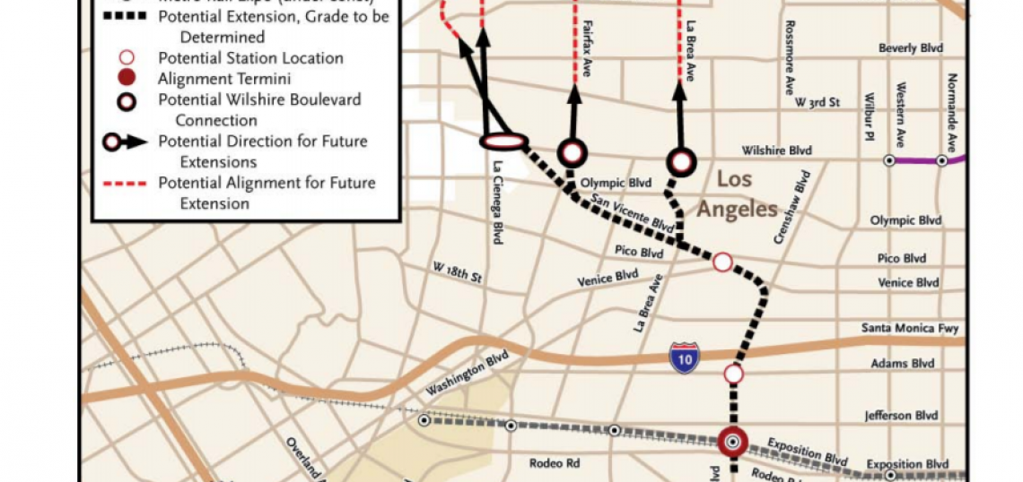
As discussed previously, Metro is considering routes for the Crenshaw Line extension that would follow La Brea, Fairfax, or San Vicente up to a terminus in Hollywood. San Vicente is favored by West Hollywood because that route would curve back onto Santa Monica Boulevard in order to connect at the Hollywood/Highland Red Line Station. Although proponents argue that San Vicente has the most destinations, and would attract the highest ridership, it is also the least direct alternative. We'll look at the options in a second, but first some perspective.
Metro's FEIR assumed the Crenshaw Line would have relatively low ridership numbers, averaging below 13,000 per weekday. This was based in part on its failure to connect with the Purple Line extension. Measure R projects were selected based on corridors identified by Metro and the Councils of Government. The political will favored building rail along Crenshaw, but with tax revenue uncertain during the recession, there was insufficient funding to build all the way to Wilshire. Parsons Brinckerhoff noted the opportunity to provide rail service further north by directing the Crenshaw Line toward Wilshire/La Brea instead of to the optional Wilshire/Crenshaw station, which was ultimately deleted from the Purple Line extension in 2010. The feasibility study projected that a 3.5-mile extension from Exposition to Wilshire/La Brea would increase ridership to 31,000 daily riders by 2030. It is worth noting that this calculation did not factor in the Regional Connector, the Expo Line to Santa Monica, or the Purple Line extension. Put another way, the Crenshaw Line would more than double its current ridership projection acting as a feeder line to a bus. This is the lens through which we should view the Crenshaw extension. In order to compare our options, it would help to first get some perspective on the position and purpose of the Crenshaw Line within Metro’s rail network.
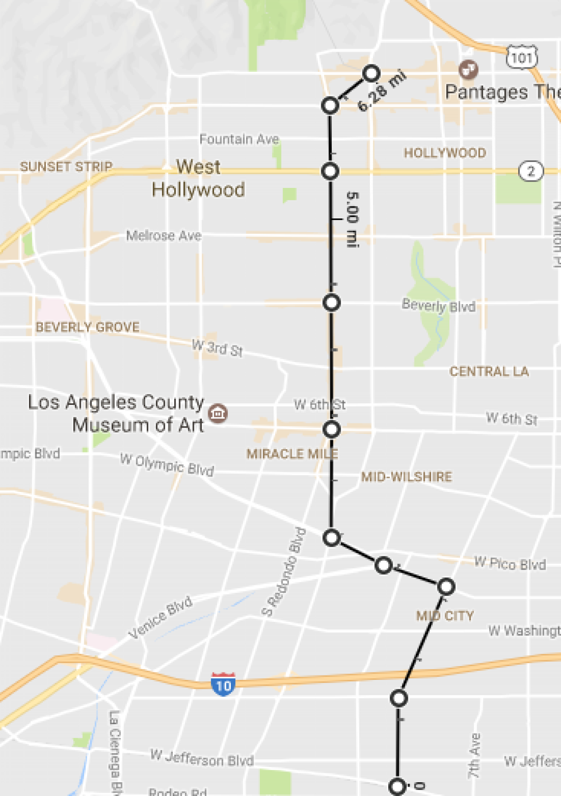
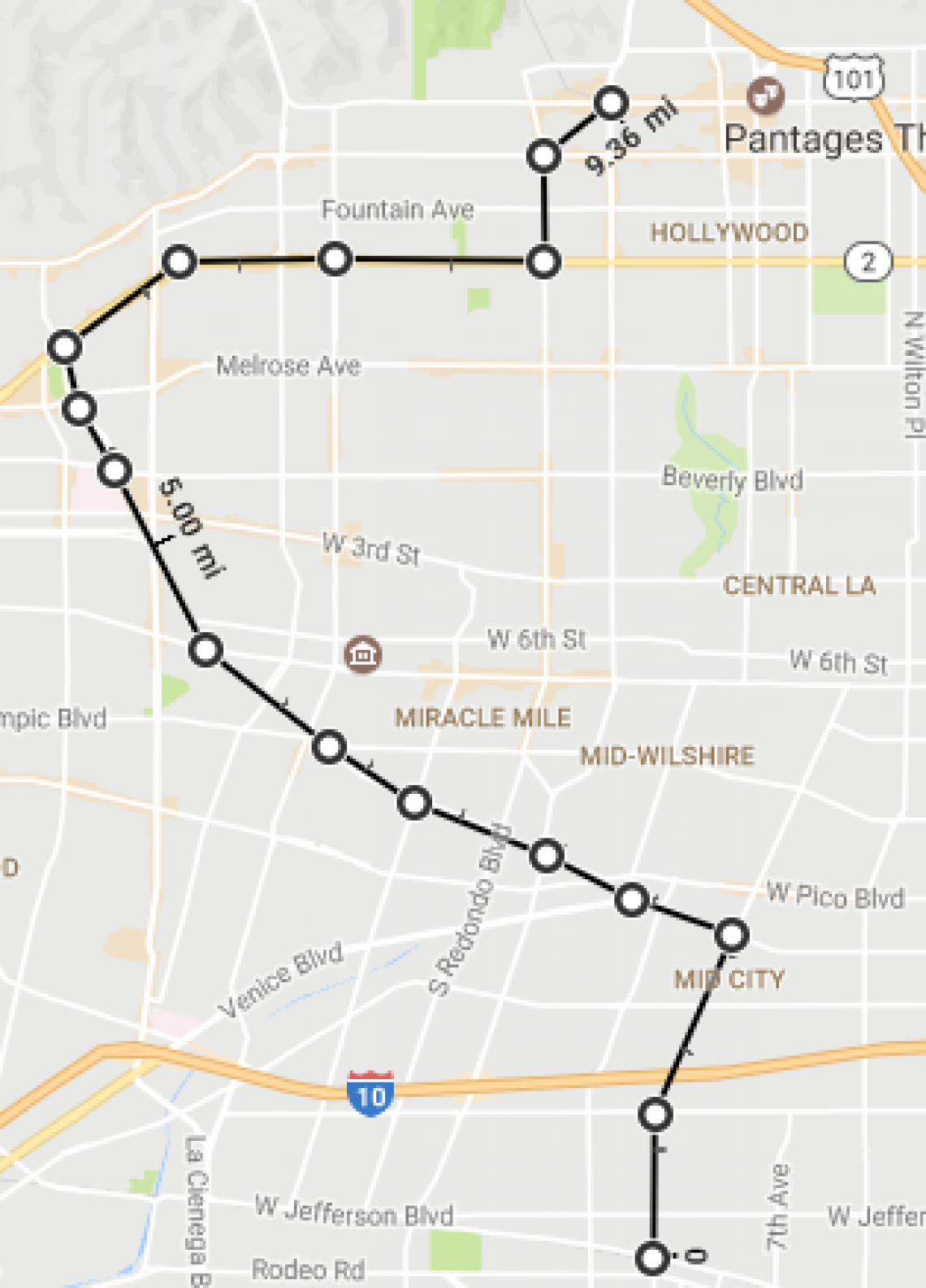
East-west travel demand between DTLA and the Westside is strong, so it makes sense that providing a direct link to the fastest, highest-capacity transit link between those two centers would yield major connectivity benefits. The more grid-like the connection, the more cost-effective the extension will be. This is especially true if Crenshaw Line riders are primarily connecting to or from the Purple Line, or using the line to bypass Downtown on their way to or from, Hollywood, the Valley, and other regions. A major ridership generator that could be served by diverting the route merits consideration, but grade-separated rail is expensive and the magnitude of such a ridership generator would have to grow with the magnitude of the diversion. Alon Levy uses for an example the decision to divert the Purple Line directly under Constellation in Century City, shown below.
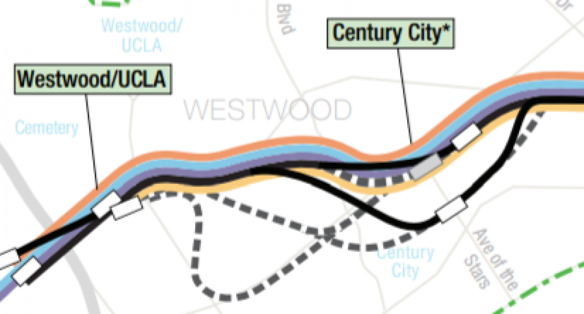
To give a sense of scale, this deviation increases route length by less than half a mile, and nearly doubles the number of jobs within ¼ mile of the station.
With that, let’s look at our options for the Crenshaw extension. As mentioned above, we should view our most direct connection as the baseline for reasons of cost and efficiency, and here that route is La Brea.
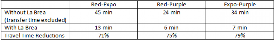
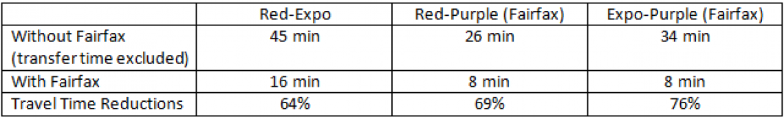
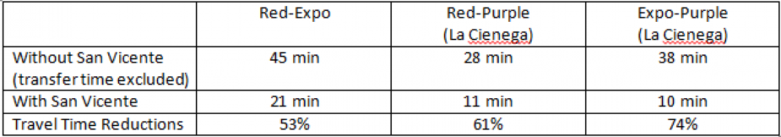
It’s rare in the history of Los Angeles’s light rail system that the baseline route for a transit project is also the fastest, the cheapest, and the most grade-separated option. That is, however, the case here. The feasibility study noted that Fairfax and La Brea have constrained rights-of-way (by L.A. standards) that would essentially rule out the possibility of running any portion of the extension at-grade along either route. If you’re a transit rider, breathe a deep sigh of relief. The La Brea route, running at Red Line speeds, would connect the Red Line and Expo Line in 13 minutes, about half the time it would take by car even in light traffic. In Los Angeles, car ownership is commonplace, distances are vast and travel demand is pent up in all directions. There is, therefore, probably no better indicator of successful transit here than speeds that beat auto speeds at their best. One of the key issues for the Expo Line is that its end-to-end travel times are competitive only when car traffic is heaviest, which even in L.A. is not all the time. Autos represent the status quo here, and getting people to change their behaviors requires giving them a reason to prefer the change. There are many sticks that can be used, but we can also work wonders with the carrot of faster travel times. As far as benefits to transit riders, here are my estimates of travel times between Hollywood/Highland, Expo/Crenshaw and Wilshire/La Brea, assuming the existence of the Purple Line extension.
Criticisms of La Brea are that it travels through the least dense neighborhoods of the three alternatives, being bordered on the east by Hancock Park, whose residents have twice successfully fought to keep a rail station from being placed at Wilshire/Crenshaw. La Brea itself contains commercial pockets, but, like all of these routes, the densest residential is at the ends. The key benefit for La Brea is its impressive time savings for riders.
If an alternative has enough ridership potential to make us pass up La Brea, it could be Fairfax. Proponents of a Fairfax alignment point out CBS studios and the Grove as major centers on that route, and note that the street has an appealing mix of high-density residential and commercial uses. On a per-mile basis, Fehr and Peers finds that Fairfax (4,518) projects for higher ridership than either San Vicente (4,433) or La Brea (4,287), but the differences are not major. The fact that Fairfax generates more of its ridership locally could potentially offset a longer end-to-end time. But those ridership gains would come with an increased project cost, due to the extra 1.5 miles of below-grade rail this alternative would require. There is a definite appeal to locating the transfer between the Purple and Crenshaw Lines at Wilshire/Fairfax. The intersection boasts a concentration of destinations, including the Grove, which is within walking distance from the Purple Line. It’s also possible that Fairfax will continue to densify faster than La Brea, but that is speculative at this point.
Finally, there is the alternative following San Vicente. It should be no surprise that much of the push for the San Vicente route has focused on the strength of the destinations in West Hollywood, because the San Vicente route basically relies on a redefinition of the purpose of the Crenshaw Line. Whereas the two previous routes focused primarily on north-south travel through Central Los Angeles, the San Vicente alternative looks fundamentally different. It really is two lines in one: A north-south line between Expo and Hollywood, and an East-West Line between West Hollywood and Hollywood.
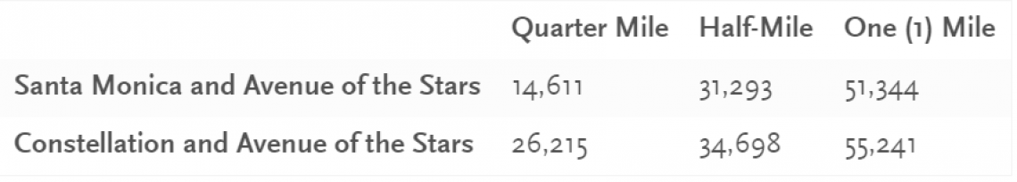
WHAM has argued that Cedars-Sinai, the Beverly Center, and the Pacific Design Center along with a host of nightlife options are strong enough ridership generators to justify the inclusion of Santa Monica Boulevard in the route. The Fehr and Peers study found that San Vicente excelled in most of the categories that it analyzed, but it did not provide per-route-mile analysis. The data presented also use employment and population figures for the entire LAX-Hollywood alignment, making it difficult to assess the value of the extensions on their own.
While West Hollywood is a tourist destination, and Cedars-Sinai is a major employer, there is nothing comparable to Century City along this route. Within the city of West Hollywood, this route would provide a heretofore-unknown ease of movement along Santa Monica Boulevard. If, though, as seems likely, the majority of the riders are not traveling to or within West Hollywood, then, in the zoomed-out view, this alternative would be providing a lesser transit value to a greater number of riders than the other two routes.
Fehr and Peers estimates that adding 2.5 miles of rail along Santa Monica would net 14,000 additional boardings per day. We should note that this is a small portion of the east-west travel demand in the Santa Monica corridor, as West Hollywood is neither the primary source nor primary destination of transit riders on Santa Monica.Buses on Santa Monica have 28,000 boardings each day. Densities on Santa Monica are highest in Hollywood and East Hollywood, and travel is bidirectional, to the Red Line or DTLA in the east, and to Beverly Hills, Century City or Westwood in the west. The West Hollywood subway does not truly address either of those travel patterns. Bus riders are unlikely to transfer to the Crenshaw Line at Santa Monica/La Brea just to transfer back to the 704 at Santa Monica/San Vicente. Any time-savings they might realize on the train would be eaten up by the two transfers and waiting time. They might end up having to wait for the bus they transferred off of to catch up with them.
Fact is, Santa Monica is a perfect corridor for rail on its own. If we include bus routes on Sunset and Melrose as representative of general travel demand for the Santa Monica corridor, the number of boardings doubles to 57,588 each day. Since buses on Santa Monica Boulevard crawl, with the Rapid averaging under 10 mph, the demand is obviously potent. It should merit consideration for a fully-grade separated line of its own, connecting, at a minimum, the Red Line and Century City, or preferably, connecting with the Purple and Sepulveda Lines in Westwood. This would provide a transit connection for West Hollywood that would also fulfill one of Jerrett Walker’s primary tenets by Being On the Way.
Given the recent history of rail transit development in Los Angeles, it seems plausible that building the San Vicente segment of the Crenshaw Line – 3-3.5 miles – at street level will be suggested at some point. Anyone thinking that at-grade rail on San Vicente will not seriously deteriorate the quality of service provided by the rail line should ride the Expo Line between Western and 7th/Metro. An at-grade segment on this line through some of the worst car traffic in the city would cause travel times to balloon and become unreliable. It would eliminate any time-savings to be had by the extension.
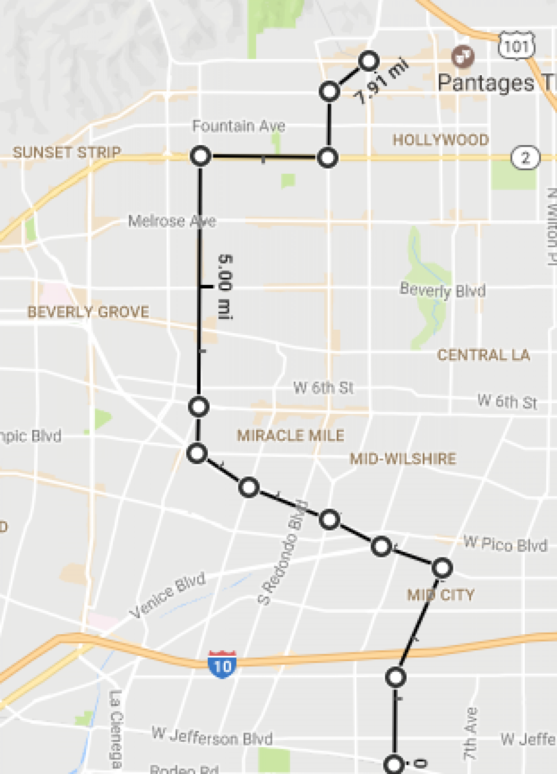
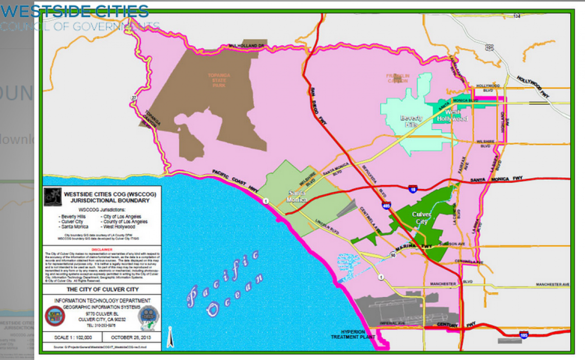
One last point worth making regarding this extension relates to the COGs. Metro’s process allowed Councils of Government, as various subregions of the county, to sponsor projects for inclusion in Measure M out of the pots of tax revenue they were expected to generate as a share of Metro’s total. The Central Los Angeles subregion threw its weight behind the Crenshaw extension. Of the $2.2 billion dollars Measure M allots to the project, the Central City subregion (the central, south, and east neighborhoods of the city of Los Angeles) is contributing nearly $1.7 billion. The Westside Cities COG, a map of which appears below, is contributing the remaining 23% of Metro’s funding. While the La Brea route runs the border between the Central City and Westside Cities subregion, the Fairfax and San Vicente alternatives veer significantly into the Westside subregion. Travel in L.A. doesn’t take arbitrary COG boundaries into account, of course, but we should be cognizant of the regional benefits of the individual alternatives. Central City voters should make it clear that any route aside from La Brea should, at a minimum, not significantly impair the utility of the extension for riders in places like Hollywood, Mid-City, and Crenshaw who sponsored this line for funding instead of many other worthwhile projects within their subregion.
With that in mind, it seems that La Brea has a lot going for it. Neither of the other two routes provide an overwhelming case for being selected over the simplest, straightest, most direct route. West Hollywood is correct that rail should be established within its borders (and a La Brea route will give them one station for a start). But such a project can only be successful if it addresses the travel patterns of Santa Monica Boulevard in a more complete manner than the Crenshaw Line could hope to. Santa Monica has its own complications, which we can address later, but it is perhaps as clear a transit corridor as can be found in the County. Metro’s Long Range Transportation Plan update is around the corner, and this is a project that transit advocates advocate be included.
Scott Frazier is a graduate student at Cal State University Los Angeles in Public Administration. Follow him on Twitter @safrazie.