
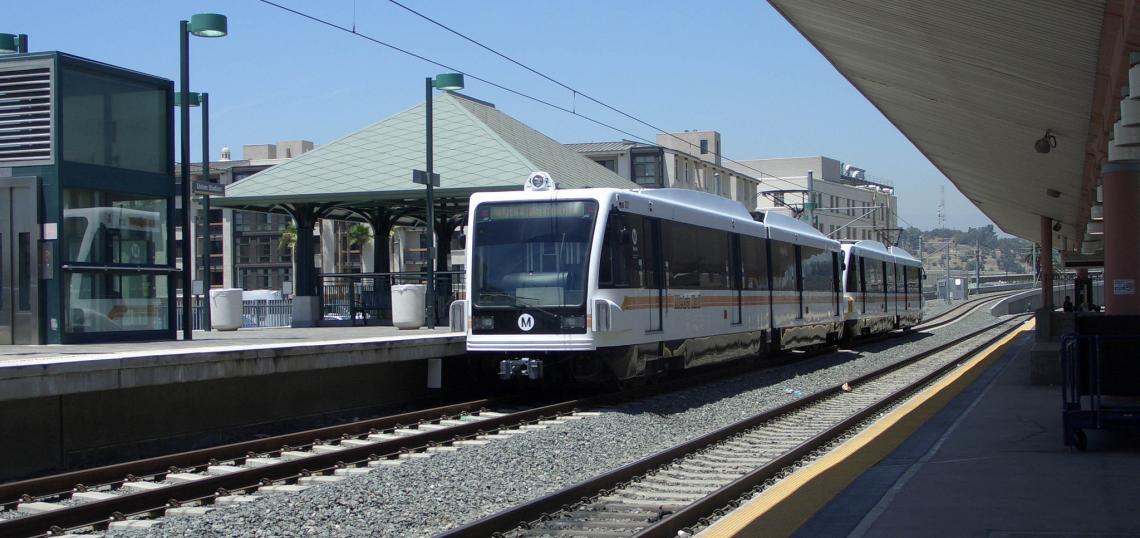
Piggybacking off of earlier work by the Southern California Association of Governments (SCAG), the Los Angeles County Metropolitan Transportation Authority (Metro) is exploring new alignments for a proposed light rail line which would shuttle passengers between Downtown Los Angeles and Artesia.
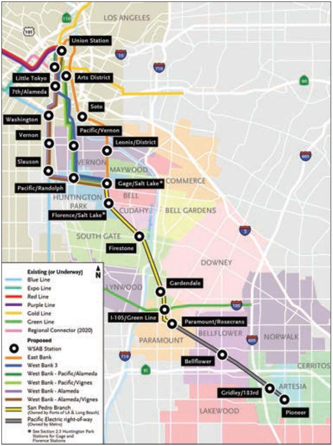
The West Santa Ana Branch (WSAB), one of 12 projects funded by the Measure R half-cent sales tax, has a scheduled revenue operation date of 2027. The prior alternatives analysis conducted by SCAG explored numerous transportation modes for the 34-mile corridor, ranging from the practical-but-unexciting (bus rapid transit) to the overly-expensive-and-unrealistic (low-speed maglev). Citing the long distance and high potential ridership along the WSAB, SCAG recommended light rail as the preferred mode and proposed two potential routes, both of which rougly paralleled the Los Angeles River.
Metro, after receiving feedback from stakeholder cities and organizations, has expanded upon those options with four additional alignments.
SCAG Alternatives
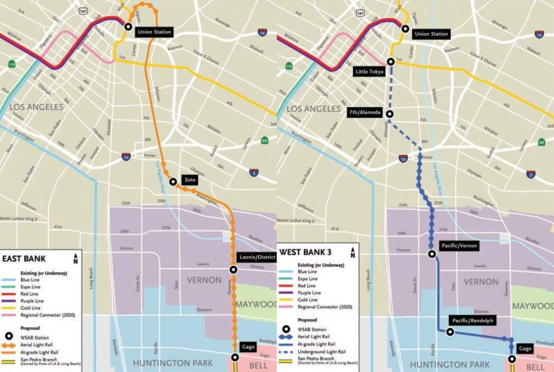
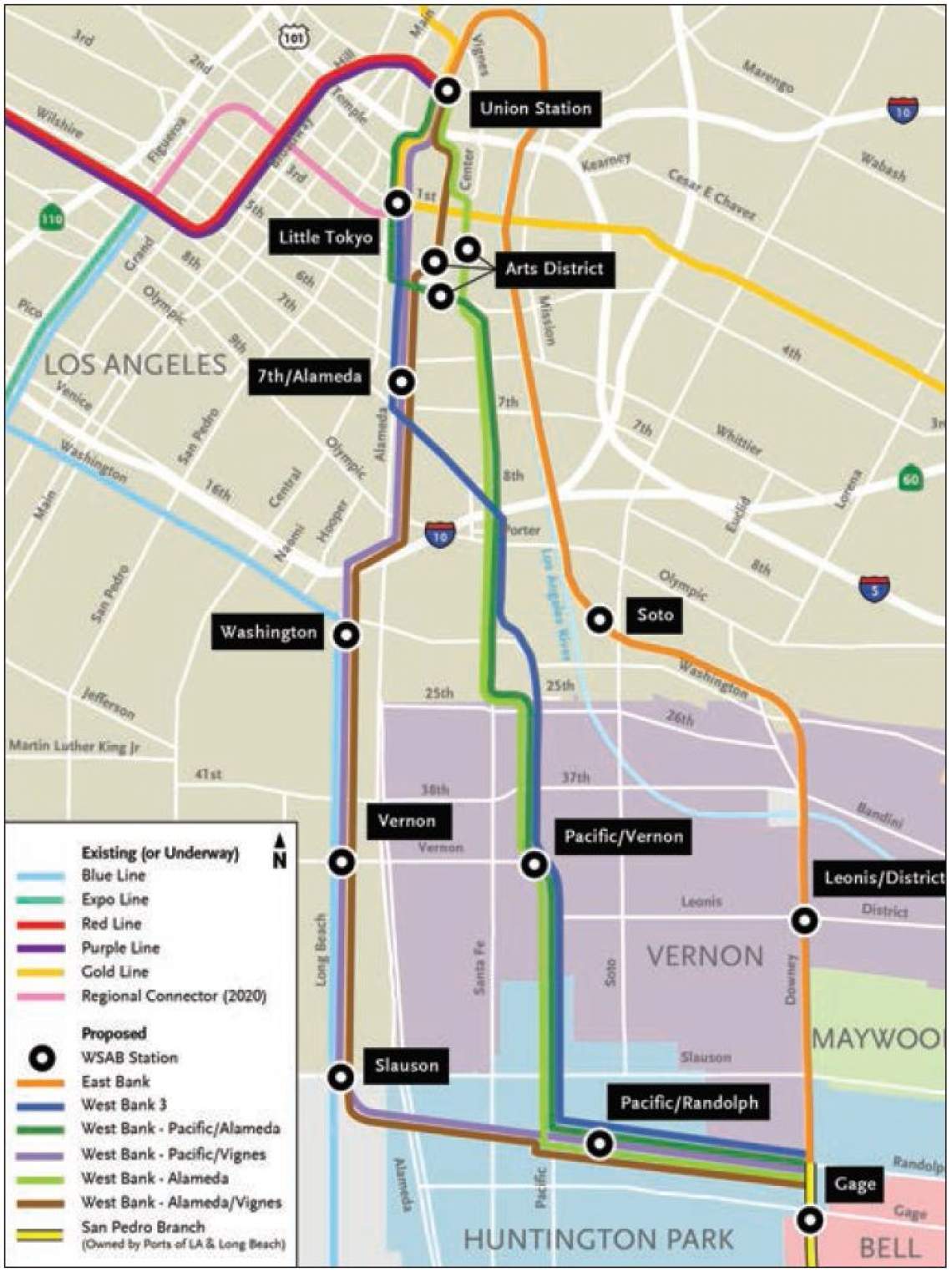
- East Bank (18.5 miles, 11 stations, 34.4 minute travel time): Trains would begin on an aerial structure at Union Station and travel south along the eastern side of the Los Angeles River within existing Metro right-of-way. They would then continue south along existing railroad right-of-way owned by others, beginning at an elevated station near Soto Street and terminating in the City of Artesia. Full grade separation is proposed in the cities of Vernon and Huntington Park along an elevated viaduct.
- West Bank 3 (17.8 miles, 12 stations, 32.4 minute travel time): Trains would begin at an underground station in Little Tokyo and continue through subway tunnels until reaching south of the I-10 freeway, at which point they would transition to an elevated structure running to Pacific Boulevard in the City of Vernon. Trains would continue on Metro-owned right-of-way until reaching the City of Huntington Park, where they would transition to existing railroad right-of-way owned by others until reaching Artesia.
Pacific Boulevard Corridor Options
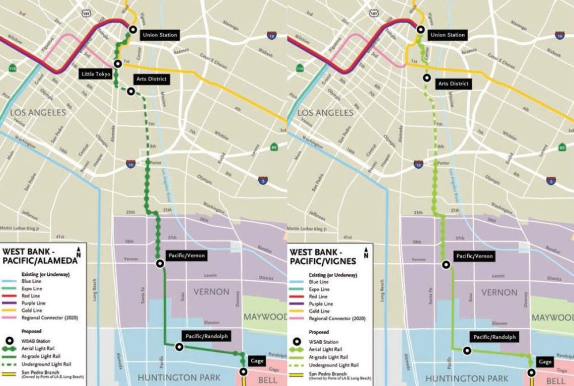
- West Bank - Pacific/Alameda (18.3 miles, 13 stations, 33 minute travel time): Trains would begin on an aerial structure at Union Station and travel south via Alameda Street before transitioning to underground tracks through the Arts District along 4th Street and Santa Fe Avenue. Trains would daylight to an aerial structure above Santa Fe Avenue south of the I-10 freeway and then travel at-grade along Pacific Avenue in Vernon. After reaching Huntington Park, trains would continue south to Artesia along existing railroad right-of-way owned by others.
- West Bank - Pacific/Vignes (18.1 miles, 12 stations, 33.2 minute travel time): Trains would begin on an elevated structure at Union Station and transition to at-grade tracks after passing the 101 freeway. After crossing south of Temple Street, trains would travel through subway tunnels below Santa Fe Avenue and then transition to an elevated structure south of the I-10 freeway. Afterwards, trains would proceed at-grade on Pacific Boulevard through the Vernon and Huntington Park, then along existing railroad right-of-way towards their terminus in Artesia.
Metro Blue Line/Alameda Street Corridor Options
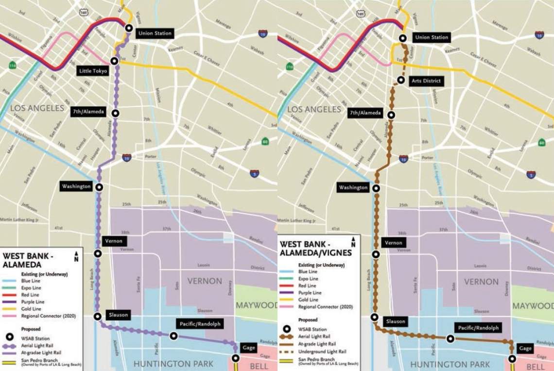
- West Bank - Alameda (19 miles, 15 stations, 33.2 minute travel time): Trains would begin at Union Station and travel south on elevated tracks above Alameda Street until transitioning to street level to cross underneath the I-10 freeway. Afterwards, trains would travel on an elevated viaduct parellel to the Metro Blue Line right-of-way towards the City of Huntington Park. From there, trains would utilize existing railroad right-of-way to reach Artesia.
- West Bank - Alameda/Vignes (19.1 miles, 15 stations, 34.3 minute travel time): Trains would begin at Union Station and travel south on an elevated structure above Vignes Street before transitioning to below-grade tracks through the Arts District. After moving towards Alameda Street, trains would continue south on elevated tracks before dropping back to street-level to pass underneath the I-10 freeway. From there, trains would travel on an elevated viaduct parallel to the Metro Blue Line right-of-way towards Huntington Park. The remainder of the trip would make use of existing railroad right-of-way towards Artesia.
Northern Terminus
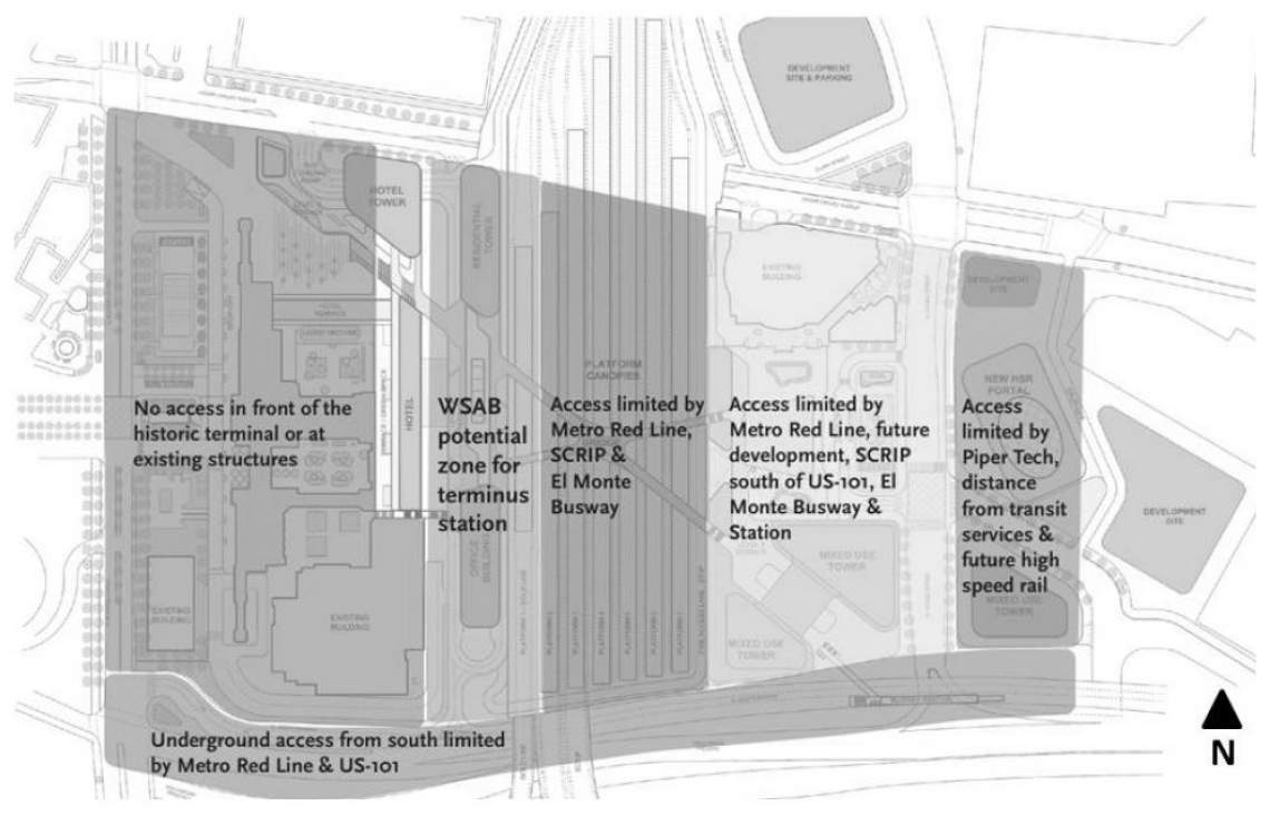
Although Union Station would be the logical northern terminus for the WSAB, a series of capital improvements planned for the historic station pose difficulties for implementation of a new rail line. Specifically, upgrades included in the Union Station Master Plan (USMP), California High Speed Rail and the Southern California Interconnector Project (SCRIP) restrict the potential locations for a new light rail platform.
Metro has identified two locations for the proposed WSAB station:
- Above the relocated bus plaza, per the USMP: a new aerial station could be constructed above the relocated Patsaouras Transit Plaza between the rail yard and the historic station building. This location would allow the light rail platform to share vertical circulation elements with the bus plaza. Although the potentially relocated bus plaza could also serve as a development site, there are no definitive plans to build a commercial development at this point in time.
- Above the Metro Gold Line Platform: an aerial station could be constructed above the existing Gold Line Station, thus allowing the new WSAB platform to share some existing vertical circulation elements. This location does not conflict with SCRIP, High Speed Rail or prospective developments.
New Stations
With new potential alignments also come new potential stations. In addition to previous options studied by SCAG, Metro staff have identified the following locations:
- Arts District (3 potential locations: One Santa Fe, 3rd Street or 4th Street)
- Washington Station (Alameda Street alternatives, on Metro Blue Line right-of-way)
- Vernon Station (Alameda Street alternatives, on Metro Blue Line right-of-way)
- Slauson Station (Alameda Street alternatives, on Metro Blue Line right-of-way)
Additionally, after consulting with the City of Huntington Park, Metro has put forth alternate station sites to those proposed by the SCAG study:
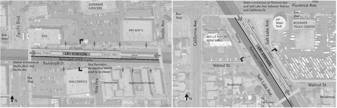
- An at-grade station on Randolph Street located east of Pacific Boulevard
- A station located south of Florence Avenue in the median of Salt Lake Avenue
New Green Line Station
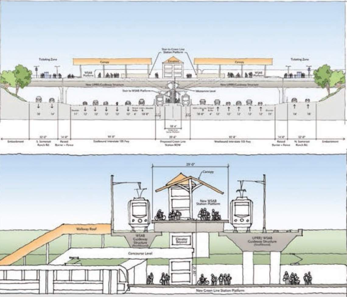
To facilitate transfers between the WSAB and the Metro Green Line, which is located in the median of the I-105 freeway, a new transfer station would be constructed midway between existing stations at Lakewood and Long Beach Boulevards.
Southern Terminus
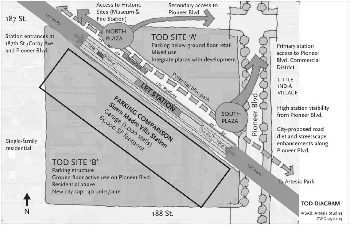
In a surprising move, the City of Cerritos requested that a proposed station on Bloomfield Avenue be dropped from consideration in future studies of the WSAB. Thus, the rail line's southern terminus would instead be located a short distance west on Pioneer Boulevard in the City of Artesia.
A concept sketch of the station site identifies two adjacent properties which could serve as a future transit-oriented development and a park-and-ride facility.
Ridership
Estimated ridership by the year 2040 for each of the alignments under study are as follows:
- East Bank: 50,759 (16,563 new trips)
- West Bank 3: 43,389 (13,449 new trips)
- West Bank - Pacific/Alameda: 59,664 (17,478 new trips)
- West Bank - Pacific/Vignes: 52,547 (16,153 new trips)
- West Bank - Alameda: 75,307 (14,254 new trips)
- West Bank - Alameda/Vignes: 61,772 (14,641 new trips)
One key factor affecting the ridership forescasts for the alignment alternatives is their ability to connect to Union Station. Los Angeles Union Station, as a hub for Metro rail, Metro buses, municipal bus operators, Metrolink and Amtrak, boosted the ridership potential of connecting alignments by as much as 30%. The West Bank 3 option, which would terminate south of Union Station, suffers from lower ridership potential as a result of this shortcoming.
Another important connection for the WSAB is the future Regional Connector station in Little Tokyo. The upcoming subway station, located at the intersection of 1st Street and Central Avenue, will offer one-seat rides to Pasadena, Long Beach, East Los Angeles and Santa Monica when completed in 2020. Accordingly, a WSAB station at 1st/Central boosts potential ridership by 14% and new transit trips by 8%.
A direct connection to the Metro Blue Line also served as a boon to ridership potential for the WSAB alternatives. Notably, the WSAB would provide Blue Line passengers with a more direct route to Union Station. The WSAB alignments would all provide a near straight-shot north to Union Station, with an approximate travel time of 9 minutes. The same trip on the meandering Blue Line - which will travel through South Park, the Financial District, Bunker Hill and Little Tokyo - would take approximately 22 minutes.
Findings
Cost estimates for the six alignment alternatives are as follows:
- East Bank: $3.79 billion
- West Bank 3: $4.31 billion
- West Bank - Pacific/Alameda: $4.42 billion
- West Bank - Pacific/Vignes: $4.41 billion
- West Bank - Alameda: $4.31 billion
- West Bank - Alameda/Vignes: $4.62 billion
After further consideration, Metro staff has recommended that the East Bank and West Bank 3 atlernatives be dropped from consideration due to significant drawbacks. This includes right-of-way constraints along the East Bank, and the inability of the West Bank 3 option to connect to Union Station.
The four new alternatives, which would travel along Pacific Boulevard and Alameda Street, are recommended to continue forward. However, they also present challenges, including concerns from the cities of Vernon and Huntington Park about impacts to freight truck traffic and the need to widen the Metro Blue Line right-of-way.
Other Issues
Like any modern rail project in a highly urbanized setting, soil conditions, utility relocation and the bureacratic maze will provide myriad obstacles for the WSAB moving forward. Additionally, the grade separation planned for the WSAB poses several challenges.
A new rail viaduct from Union Station over the 101 freeway will require the approval of Caltrans, while similar aerial structures along the proposed routes will need sign-offs from organizations such as the Union Pacific Railroad, the Southern California Regional Rail Authority and the twin Ports of Los Angeles and Long Beach.
Property acquisition may be necessary to widen the right-of-way in certain areas and to establish a maintenance facility for light rail vehicles.
As several sections of the WSAB may run below street level, construction of the rail line could impact nearby buildings.