In 2022, construction is scheduled to begin for the first phase of the West Santa Ana Branch (WSAB), a $6.6-billion light rail line stretching into Southeast Los Angeles County. In advance of that date, Metro has released a "Transit Oriented Development Strategic Implementation Plan," which provides guidelines for land use and active transportation improvements surrounding each station between the City of Artesia and Downtown Los Angeles.
Pioneer Station

Pioneer Station, the southern terminus of the WSAB, is located on the finger of Artesia Little India community. Building off of this existing activity hub, the station area plan envisions buildings ranging between four and seven stories in height, featuring ground-level retail, second-level office space, and residential units located above.
Recommendations for station area include:
- the creation of an overlay zone to enable streamlined project approvals;
- the development of a 1,200-space shared parking structure for the area;
- implementing strategies to retain existing family-owned and independent businesses;
- improving connections to Artesia Park; and
- construction of an active transportation path flanking the WSAB right-of-way.

Bellflower

Bellflower Station will sit at the northwest corner of Pacific Avenue and Bellflower Boulevard - a major commercial corridor. Recent public investments in the surrounding area include the construction of The Mayne Events Center and the Los Angeles County Fire Museum. These have been complemented by the construction of the SteelCraft Development - a food court and brewery built from repurposed shipping containers.
The City of Bellflower is already developing a specific plan for the area surrounding the station. To guide that effort, Metro's implementation plan recommends:
- taking proactive measures to prevent the displacement of existing businesses;
- incentivizing property owners to redevelop surface parking lots into other uses such as mixed-use residential;
- exploring parking management strategies such as a shared parking district or a reduction of parking requirements;
- building an active transportation path adjacent to the WSAB right-of-way; and
- adding new sidewalks to Flora Vista Street between Bellflower Boulevard and Cornuta Avenue.

Paramount/Rosecrans

Paramount/Rosecrans Station, named for its location at the intersection of Paramount Boulevard and Rosecrans Avenue, will sit in closer proximity to the Paramount Drive-In Theater and Swap Meat and the Bianchi Theater multiplex. The City of Paramount has drafted a vision plan for the station area, adding housing and public open space while transitioning existing industrial sites to "green" technology uses.
Recommendations include:
- targeting the parking lot flanking the drive-in theater for redevelopment with mixed-income housing;
- implementing pedestrian safety improvements at Rosecrans and Paramount;
- pursuing strategies such as shared parking or reduced parking requirements;
- creating a network of open spaces centered on the station;
- building a mobility hub at the station;
- lining the WSAB right-of-way with an active transportation path; and
- planning a north-south active transportation park through Paramount Park between 3rd Street and the WSAB right-of-way.

I-105/Green Line

The I-105/Green Line Station, the proposed transfer point between the WSAB and the Green Line, sits on the border of the Cities of South Gate and Paramount. Metro's station area plan indicates potential for non-traditional industrial and mixed-use buildings to provide a transition to the adjacent residential neighborhood.
Recommendations include:
- public realm improvements to enhance the experience of transit passengers;
- active transportation connections to the Garfield retail corridor and nearby parks;
- the creation of public parking garages for use by transit passengers; and
- an active transportation across the I-105 Freeway;

Firestone

Firestone Station is slated for the northeast corner of Firestone Boulevard and Atlantic Avenue, an intersection located in the City of South Gate and in close proximity to the City of Cudahy. South Gate has already adopted a specific plan for the immediate surroundings in anticipation of the WSAB, and Cudahy is now considering the development and a casino nearby. By redeveloping nearby industrial sites, Metro envisions that the station could become the center of a mixed-use center, driven by the adjacent Azalea Shopping Center.
Recommendations include:
- improving non-motorized transaction at the intersection of Atlantic and Firestone;
- upgrading pedestrian connectivity to Cudahy's entertainment district;
- providing light industrial, office, and flex spaces to provide a range of employment options;
- exploring parking management strategies;
- working to mitigate potential future displacement of residences and businesses;
- building an active transportation path adjacent to the WSAB right-of-way with connections to the L.A. River;

Florence/Salt Lake

The Florence/Salt Lake Station, slated for the intersection of the same name, would be located in the City of Huntington Park, which abuts both Cudahy and Bell. Metro's concept envisions that existing automotive uses will transition to neighborhood-serving uses, potentially through a mixed-use overlay zone being considered by the City of Huntington Park.
- leveraging the adjacent park to attract sports-supporting uses;
- redevelop parcels on the south side of Florence Avenue with mixed-use and multi-family buildings;
- taking proactive measures to support equitable growth and prevent displacement;
- improving neighborhood parking and pedestrian realm;
- building an active transportation path adjacent to the WSAB right-of-way; and
- using the transmission line right-of-way located west of California Avenue to provide station access.

Pacific/Randolph

Pacific/Randolph Station would serve the historic main street of Huntington Park. The station area plan identifies several opportunities for adaptive reuse projects, as well as infill development by repurposing large-format retail properties and subdividing them to create permeable blocks.
Recommendations for the Pacific/Randolph Station Area include redeveloping surface parking lots lining Pacific Boulevard and taking proactive measures to support equitable growth and mitigate potential future displacement.

Slauson

The WSAB's Slauson Station would abut an existing Blue Line stop of the same name. The station site would intersect with the active transportation rail-to-river corridor project, which will convert a portion of the Harbor Subdivision freight rail right-of-way into a bike and pedestrian path between Inglewood and the Los Angeles River. The station area concept identifies several manufacturing sites that could potentially be reused following remediation.
The station, which is located in the unincorporated Florence-Firestone community, also sits in closer proximity to the Cities of Los Angeles, Huntington Park, and Vernon. In anticipation of the coming station, the County has already initiated a new specific plan for the area. Metro's recommendations for the surroundings include:
- pursuing strategies to mitigate displacement;
- considering policy changes to encourage green technology, bio-tech, advanced manufacturing, and other uses;
- redeveloping older and underutilized industrial parcels with mixed-use projects; and
- exploring new parking strategies for the neighborhood, including a shared parking district and reduced parking requirements.

Arts District South

The Arts District South Station would be located on the eastern side of Downtown Los Angeles near the intersection of 7th and Alameda Streets. Existing uses near the station site include ROW DTLA, the L.A. Produce Market, a Greyhound Station, and Metro's Division One bus yard. Several large mixed-use projects are either approved or pursuing entitlements in the near vicinity, including SunCal's 6AM development and AvalonBay Community's AVA Arts District.
In coordination with the ongoing DTLA 2040 update to the Central City and Central City North Community Plans, Metro's station area concept envisions a mix of adaptive reuse and ground-up developments in the surrounding area.
Recommendations include:
- focusing on public realm investments, first/last mile connectivity, and affordable housing;
- placing emphasis on multi-modal connectivity by sub-dividing large parcels with public right-of-way;
- facilitating adaptive reuse projects; and
- working with property owners to incorporate the station into their development plans to facilitate access for transit users.

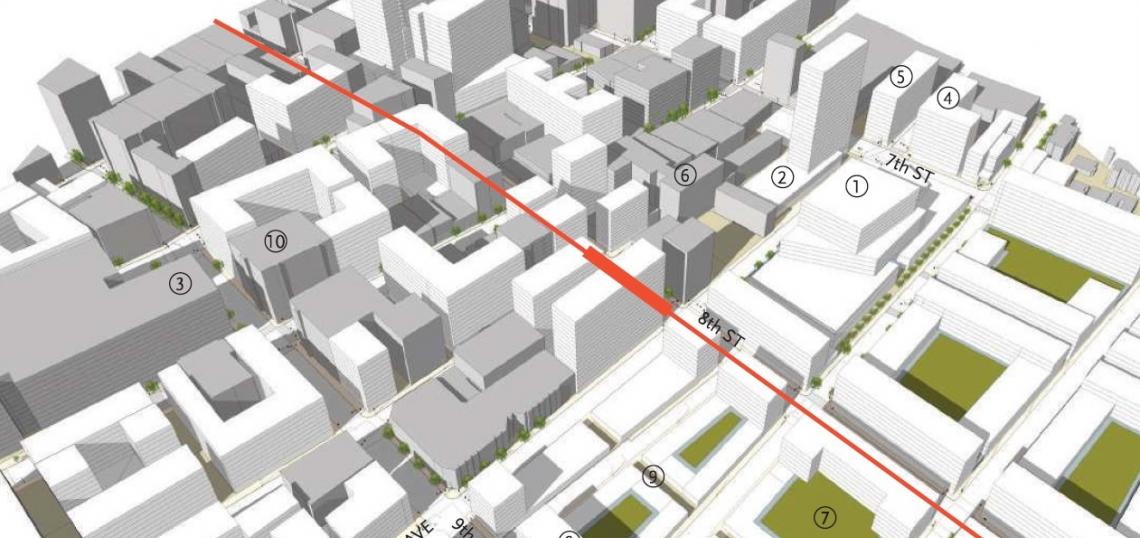
South Park/Fashion District

Should 7th Street/Metro Center be selected as the northern terminus of the WSAB, the proposed South Park/Fashion District Station would be built near the intersection of Maple Avenue and 8th Street. The intersection abuts Santee Village - a collection of mid-rise commercial buildings that have been repurposed as housing - and sits in close proximity to a large collection of retailers, wholesalers, designers, and other fashion-related businesses.
The station area concept anticipates that future development in the Fashion District would be similar to recently-completed projects in the neighborhood such as the Broadway Palace Apartments. Metro's recommendations include:
- implementing policies to ensure the continued success of existing buildings as the neighborhood transitions;
- prioritize the adaptive reuse of existing buildings;
- explore innovative parking management strategies; and
- redevelop large surface parking lots with higher-density mixed-use buildings.

Little Tokyo

The optional Little Tokyo Station, which would be built if Union Station is selected as the WSAB's northern terminus, would abut the station now being built at 1st Street and Central Avenue. The neighborhood, the historic center of the Southern California Japanese-American community, is poised for the development of new housing and commercial space through both the DTLA 2040 and Sustainable Little Tokyo efforts.
In light of this, Metro's recommendations for the Little Tokyo area include:
- sustaining existing businesses and residents;
- prioritizing access and connectivity to both the WSAB and the Regional Connector;
- redeveloping large surface parking lots northeast of the station;
- pursuing new parking management strategies; and;
- subdividing large blocks to allow for greater permeability.


A staff presentation given at the October 17 meeting of the Metro Board Planning and Programming Committee detailed elements of the program. If the Board adopts a staff recommendation, Metro would be authorized to enter into agreements with cities along the West Santa Ana Branch corridor for implementation of the strategic plan.
- West Santa Ana Branch (Urbanize LA)