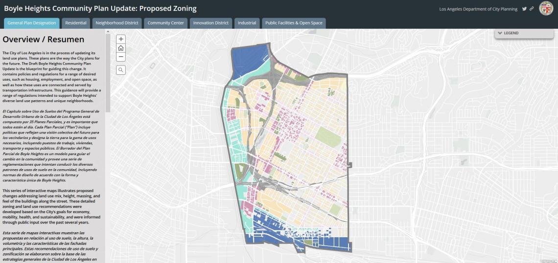
The Los Angeles Department of City Planning has unveiled an interactive map for the Boyle Heights Community Plan update, allowing residents to visualize proposed land use and zone changes.
Though released just earlier this month, work on the community plan update dates back to 2006. The start of that process coincided with the onset of the Great Recession, which led to budget cuts and staffing shortages at the Planning Department. Work would be put on hold shortly afterward, and would not resume until 2012.
The update comes as tensions continue to rise in Boyle Heights over gentrification, with a regional housing shortage putting pressure on the working class Latino enclave. The Planning Department, aware of the growing unease amongst many residents, has attempted to craft a plan that permits growth while limiting displacement and ameliorating the problems created by the neighborhood's industrial fringe.
With an average household income of just over $33,000 per year, Boyle Heights is among the poorest communities in Los Angeles. The bulk of these households are renters, with just a 24.1 percent homeownership rate for the neighborhood - also among the lowest figures in the City. With this reality in mind, residents of Boyle Heights have looked across the L.A. River at the growing Downtown skyline with unease over the past several years, fearful that the Central City's development boom would spread to the Eastside and spur displacement.
The Planning Department has answered these concerns with a draft plan that concentrates new density within a roughly 140-acre district centered on the intersection of 1st and Soto Streets while proposing little in the way of change for the rest of the community. This area is home to two stations on Metro's Gold Line, as well as numerous local and rapid bus lines. The presence of these transit lines makes properties in this area eligible for the Transit Oriented Communities incentives, which allow additional height and density in exchange for creating subsidized affordable housing.
Nonetheless, new construction is still encouraged to be compatible with the surrounding neighborhood, which features many buildings that date back to the 19th century. Building heights are regulated above 45 feet, with any additional floors required to be set back from the street frontage.
Additionally, the plan acknowledges the multigenerational households that comprise much of Boyle Heights and is thus tailored to accommodate accessory dwelling units through reduced rear yard setback requirements. This is in keeping with the existing built environment, which already features numerous "granny flats."
Notably absent from the transit district is the Mariachi Plaza station area. To explain this, the Planning Department cites a recent study by Survey LA, which found that the area bounded by the US-10, US-101 and I-5 freeways could be eligible for a historic preservation overlay zone (HPOZ). An HPOZ, if established, would place limits on new construction and demolition of existing buildings within the associated area.
Plans for a large medical office building and mixed-use complex on Metro-owned property surrounding the station drew the ire of residents two years ago for a multitude of reasons, most notably a lack of community outreach. The blowback eventually prompted Metro to scrap the project and start the process anew.
The industrial district abutting the L.A. River, currently a center of controversy due to a recent proliferation of art galleries, is imagined with lower intensity industrial uses than in years past. For example, the south side of Olympic Boulevard could see a business such as a mattress store with an attached mattress manufacturing facility in the back. This new industrial buffer zone would also allow for housing to activate the opposite side of Olympic.
Citing demand from the community, the Planning Department is incorporating a requirement for outdoor amenity space in the River-adjacent "Innovation District," which is located on the far west side of the plan area between 1st and 7th Streets. New construction with publicly accessible open space - such as courtyards and plazas - would be subject to a less stringent requirement.
Lastly, the draft Boyle Heights Plan is informed by the Clean Up Green Up initiative (CUGU), which was adopted by the City of Los Angeles in 2016. CUGU - which covers Boyle Heights, Wilmington, and Pacoima - looks to reduce mitigate pollution by industrial uses in close proximity to residential communities by enforcing "good neighbor" rules on existing businesses, preventing new businesses from opening without meeting environmental health standards, and providing a funding stream to clean up pollution hotspots. While CUGU previously applied to Boyle Heights as an overlay, the new plan incorporates the program into the zoning code.
Additional information about the Boyle Heights Community Plan, including the dates and location os any future meetings or pop up hearings, is available as the project's official website.
- Boyle Heights Community Plan (Official Website)